If you’re submitting a planning application in the UK, getting your location plan right is essential.
A non-compliant plan is one of the fastest ways to delay your application.
This guide explains exactly what’s required — in plain English — so you can get it right first time.
What Is a Location Plan?
A location plan shows where your site sits within its wider surroundings.
It helps the local planning authority understand:
- where your property is located
- how it relates to nearby roads and buildings
- the boundaries of the application site
It is a mandatory document for almost all planning applications.
👉 Need one now? Visit our website and get your location plan.
UK Location Plan Requirements (Essential Checklist)
To be accepted by your council, your location plan must meet strict criteria.
1. Correct Scale
Your plan must be drawn at one of these standard scales:
-
1:1250 (urban areas)
-
1:2500 (rural areas)
Anything else will likely be rejected.
2. Clear Red Line Boundary
You must outline the application site with a red line.
This should include:
-
all land required for the development
-
access routes
-
gardens or extensions
3. Blue Line (If Applicable)
If you own additional land nearby, it should be marked with a blue line.
This is often missed, and can cause validation issues.
4. North Point
Every plan must include a north arrow.
Without it, planners cannot orient the site correctly.
5. Surrounding Features
Your plan must show:
-
nearby roads
-
neighbouring buildings
-
street names
This gives planning officers proper context.
6. Up-to-Date Mapping
Outdated maps are not acceptable.
You must use current Ordnance Survey-based mapping.
Why Location Plans Get Rejected
Understanding common mistakes can save weeks of delays.
Incorrect Scale
Submitting a plan at 1:500 or 1:200 is a frequent error.
These are used for block or site plans, not location plans.
Missing or Faint Red Line
If your boundary is unclear, your application may be invalidated.
Cropped or Incomplete Maps
Plans must include enough surrounding area, not just your property.
Non-Standard Maps
Google Maps screenshots are not acceptable.
You must use proper planning-compliant mapping.
Step-by-Step: How to Create a Compliant Location Plan
Step 1: Find Your Property
Search your address or postcode using a planning map provider.
Step 2: Select the Correct Scale
Step 3: Draw the Red Line Boundary
Carefully outline:
-
your property
-
any land affected by the proposal
Step 4: Add Required Details
Ensure your plan includes:
-
north arrow
-
road names
-
surrounding buildings
Step 5: Download in PDF Format
Most councils require a PDF for submission via the Planning Portal.
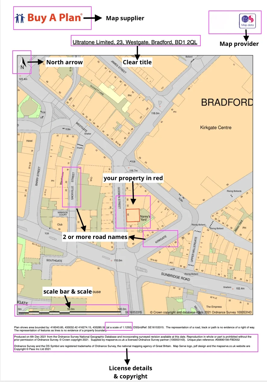
Example of a Good Location Plan
A compliant plan should:
-
clearly highlight the site
-
show nearby roads
-
include a visible scale and north arrow
-
be easy to read when printed
When Do You Need a Location Plan?
You’ll need one for:
-
house extensions
-
loft conversions
-
new builds
-
change of use applications
In short — almost every planning application.
How Much Does a Location Plan Cost?
Typical pricing:
- £10–£30 for a standard plan
- higher for large or complex sites
The cost is small compared to delays caused by rejection.
Location Plan vs Block Plan (Quick Difference)
|
Feature |
Location Plan |
Block Plan |
|
Scale |
1:1250 / 1:2500 |
1:200 / 1:500 |
|
Purpose |
Show site location |
Show site layout |
|
Detail Level |
Low |
High |
You usually need both.
Pro Tips to Avoid Planning Delays
-
Always double-check scale before download
-
Ensure the red line fully encloses the site
-
Include access routes if relevant
-
Don’t edit or crop official maps
FAQs
1. What scale should a location plan be in the UK?
Typically 1:1250 for urban areas and 1:2500 for rural areas.
2. Can I use Google Maps for a planning application?
No. Only Ordnance Survey-based plans are accepted.
3. Do I always need a red line boundary?
Yes. It’s a mandatory requirement.
4. What happens if my plan is wrong?
Your application may be rejected or delayed during validation.
5. Can I draw my own location plan?
Technically yes, but it must meet strict standards, which most DIY plans fail.
Get Your Location Plan in Minutes
Avoid delays and get a fully compliant plan ready for submission.