Submitting a planning application?
Then your location plan isn’t just a formality, it’s a pass/fail document.
Many applications are rejected before review simply because the location plan doesn’t meet validation rules.
This guide gives you a simple checklist to make sure your plan is accepted first time.
Why a Checklist Matters
Planning departments don’t “review” your application straight away.
First, they validate it.
If anything is missing or incorrect:
- Your application is returned
- You lose time (often weeks)
- You may need to repay or resubmit documents
A checklist helps you avoid all of that.
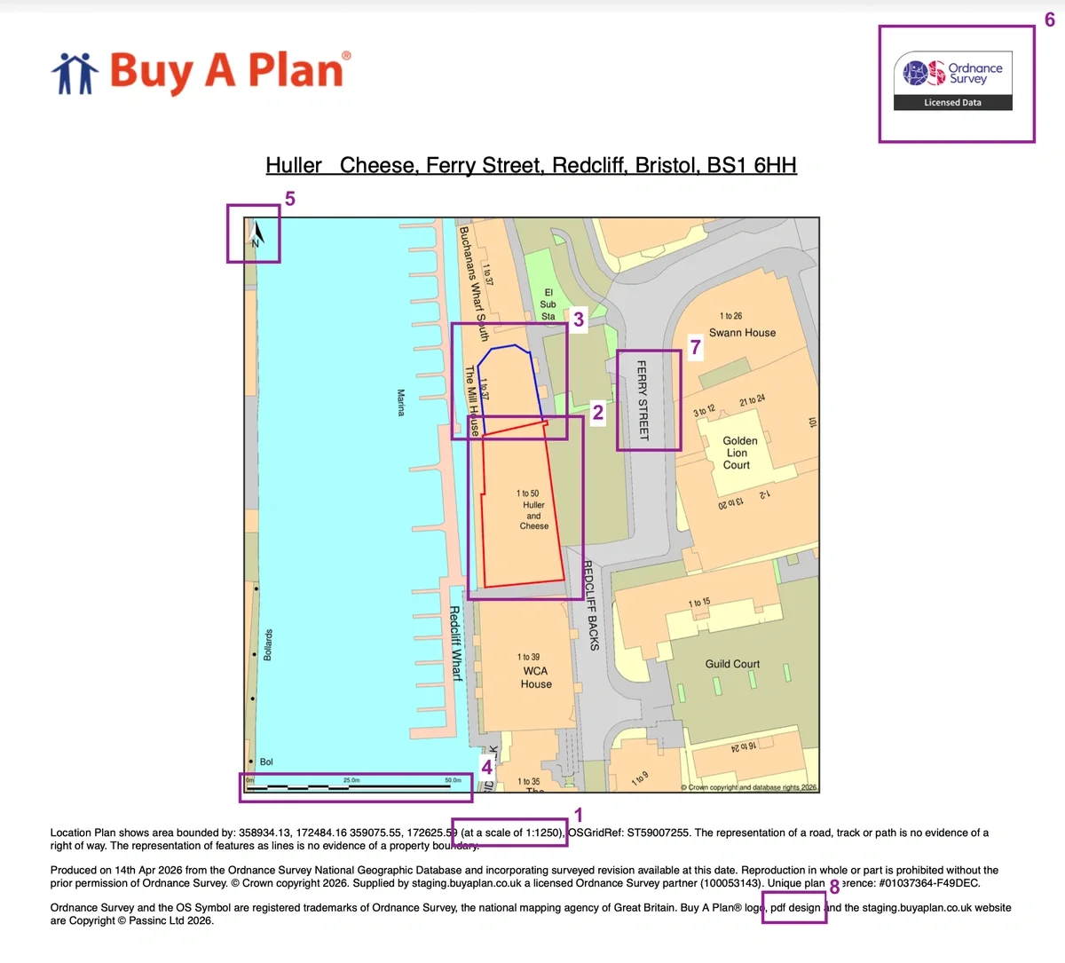
The Ultimate Location Plan Checklist
Use this before you submit your application.
✅ 1. Correct Scale Selected
Your plan must be:
- 1:1250 (most common)
- 1:2500 (large or rural sites)
Anything else is likely to fail validation.
✅ 2. Red Line Boundary Is Accurate
Check that your red line:
- Covers the entire development site
- Includes access routes
- Matches your application description
Even small omissions can cause rejection.
✅ 3. Blue Line (If Applicable)
Include a blue line if:
- You own nearby or adjoining land
This is often required but frequently missed.
✅ 4. Scale Bar Is Visible
This is a big one.
You must include:
- A scale ratio (e.g. 1:1250)
- AND a scale bar
Many applicants forget the scale bar — and get rejected.
✅ 5. North Arrow Included
Your plan must show:
- Direction (north arrow)
Without it, planners cannot properly interpret orientation.
✅ 6. Based on Ordnance Survey Mapping
Your plan must:
- Use licensed mapping data
Not allowed:
- Google Maps
- Screenshots
- Sketches
✅ 7. Surrounding Features Are Clear
Your plan should clearly show:
- Roads
- Buildings
- Nearby landmarks
If the site can’t be easily located, it may fail validation.
✅ 8. PDF Format & High Quality
Ensure your file:
- Is clear and readable
- Not blurry or pixelated
- Submitted as a PDF
Real Example: Why Applications Get Rejected
A homeowner submits an extension application.
Their location plan:
- Uses the correct scale
- Shows a red boundary
But…
They forgot:
- The scale bar
- Part of the driveway in the boundary
Result:
👉 Application invalidated
👉 2-week delay
👉 Resubmission required
How to Validate Your Own Plan (Quick Test)
Ask yourself:
- Can someone unfamiliar find the site instantly?
- Is the boundary 100% complete?
- Are all required elements visible?
If not, fix it before submitting.
The Fastest Way to Get It Right
Instead of manually creating plans, use a tool that:
- Automatically applies correct scale
- Includes all required elements
- Uses compliant mapping
👉 Create your location plan here.
Location Plan vs Block Plan (Quick Reminder)
Many people confuse these:
- Location plan → shows site in wider area
- Block plan → shows site in detail
You usually need both.
FAQs
1. What is the most important part of a location plan?
The red line boundary — it must be complete and accurate.
2. Do I need a scale bar as well as scale?
Yes — both are required for validation.
3. Can I edit a location plan myself?
Yes, but mistakes are common. Using a tool reduces risk.
4. How do I know if my plan is valid?
Follow a checklist like this — or use a compliant generator.
5. Do all councils have the same requirements?
Most follow the same national validation standards.