If you are submitting a planning application, one of the most common questions is:
What scale should a location plan be for planning permission?
Using the wrong scale can delay your application, cause validation issues, or force resubmission.
This guide explains the correct UK location plan scales, when to use them, and how to order a compliant map quickly.
What Is a Location Plan?
A location plan shows:
- Your property
- Nearby roads
- Surrounding buildings
- Site boundaries
- The wider area around the site
It helps the local planning authority clearly identify where development will take place.
A location plan is different from a site plan—it shows the broader context, not detailed layout.
What Scale Should a Location Plan Be?
In most UK planning applications, the standard scale is:
1:1250
This means:
1 cm on the plan = 12.5 metres in reality
Used for:
- Houses
- Extensions
- Loft conversions
- Garages
- Residential applications
When Is 1:2500 Used?
A 1:2500 scale is typically used when:
- The site is rural
- Land is larger
- Agricultural plots
- Barn conversions
- Large developments
This scale covers a wider area but with less detail.
1 cm on plan = 25 metres in reality
Which Scale Is Best for Your Application?
Use 1:1250 if:
- Standard residential property
- Town or suburban location
- Single dwelling application
- Home improvements
Use 1:2500 if:
- Large site or land parcel
- Countryside location
- Farm or agricultural buildings
- Land division projects
If unsure, always check your council’s validation checklist.
What Must Be Included on a Location Plan?
Your plan should include:
- Red line boundary – outlines the application site
- Blue line boundary – other land you own nearby
- Road names – clearly labelled
- North point – required for orientation
- Recognised scale – typically 1:1250 or 1:2500
- Clear quality – readable and not pixelated
Can You Use Google Maps?
Usually not.
Google Maps screenshots often fail because they:
- Are not to a recognised scale
- Lack a proper scale bar
- May breach copyright
- Are low quality
- Miss required boundaries
For planning applications, it is safer to use a professional plan.
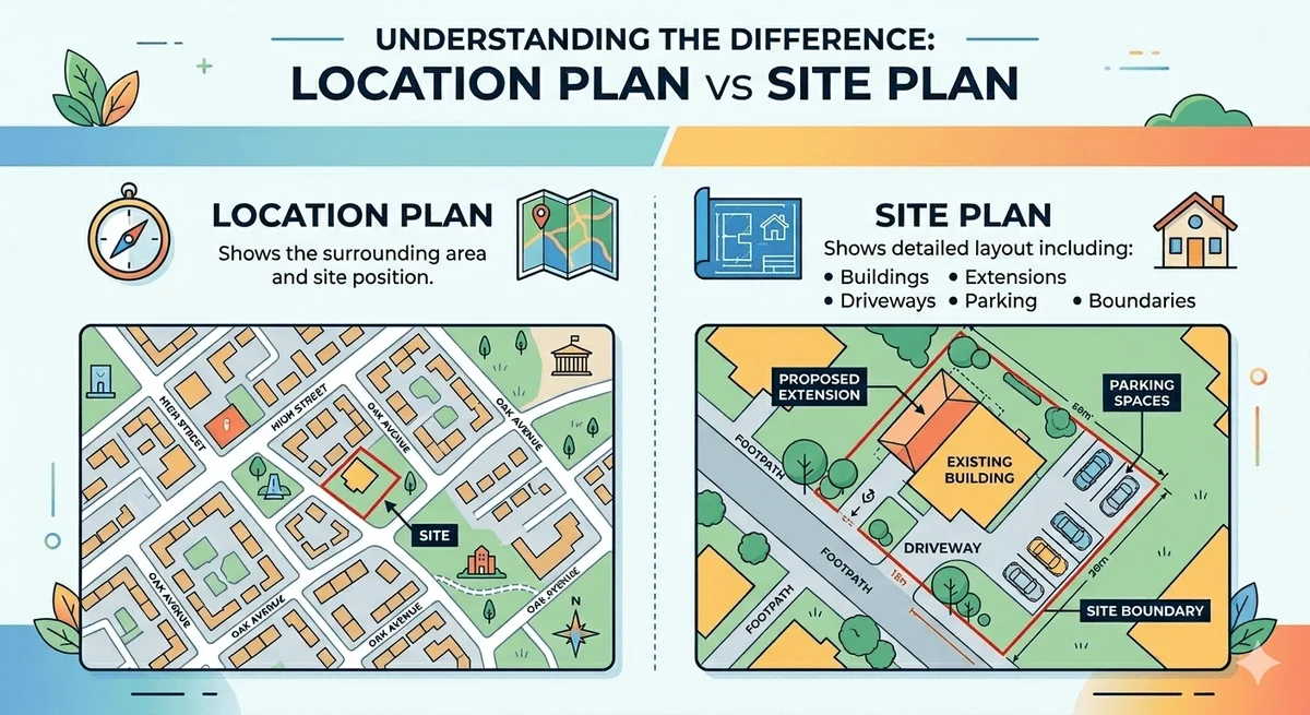
Location Plan vs Site Plan
Many applicants confuse the two.
Location Plan
Shows the surrounding area and site position.
Site Plan
Shows detailed layout including:
- Buildings
- Extensions
- Driveways
- Parking
- Boundaries
You will often need both.
How to Order the Correct Scale Plan
With BuyAPlan, you can order a compliant plan in minutes:
- Enter your postcode
- Select your property
- Choose 1:1250 or 1:2500
- Add your red boundary
- Download instantly
This is far quicker than creating plans manually.
Common Reasons Plans Get Rejected
- Wrong scale
- Missing red boundary
- Poor quality screenshots
- Missing roads or labels
- Outdated or low-resolution maps
Example: House Extension in London
For a typical semi-detached home:
Recommended plan:
- 1:1250 scale
- Red boundary around house and garden
- Road names visible
- North arrow included
This will usually meet council requirements.
How Much Does a Location Plan Cost?
Costs vary depending on:
- Scale selected
- Download or print option
- Additional plans required
Compared to delays, the cost is usually minimal.
Why Choose BuyAPlan?
BuyAPlan helps UK homeowners and developers get planning-ready maps quickly.
Benefits:
- Fast online ordering
- Correct planning scales
- Editable boundary tools
- Instant downloads
- Designed for UK planning requirements
FAQs
1. What is the standard location plan scale?
Usually 1:1250 for residential and 1:2500 for larger sites.
2. Can I choose any scale?
No. Councils require recognised mapping scales.
3. Do all councils follow the same rules?
Most are similar, but always check local validation requirements.
4. Do I need a site plan too?
Often yes, especially for extensions or new builds.
5. Can I draw my own plan?
Yes, but professional plans reduce rejection risk.
Ready to Order?
Need the correct location plan scale?
Check our location plans and order a compliant map in minutes.